WarViews: Visualizing and Animating Geographic Data on Conflict
Nils B. Weidmann, International Conflict Research, ETH Zurich
Doreen Kuse, Institute for Cartography, Dresden Technical University
--- NEWS ---
October 2011:
The original WarViews server has been superseded by a KML-only version. Please go to http://nils.weidmann.ws/projects/warviews for more information.
January 2011:
The WarViews server is currently down as a result of an attack. We are working to get the problem fixed. Stay tuned.
November 2008:
We are now using a GoogleMaps layer in the static version of WarViews.
WarViews is discussed in the recent Maps for Advocacy brochure.
September 2008:
WarViews article in International Studies Perspectives
June 2008:
Balkans coverage of ACLED added to WarViews
April 2008:
WarViews article in GIS BUSINESS
January 2008:
WarViews article in the TAGESANZEIGER >>
December 2007:
ETH LIFE article about WarViews: English German
Short introduction
In recent years, the field of conflict research has produced important findings on the relation between conflict and geography. For this purpose, new datasets have been created with the help of GIS software. These datasets include variables relevant for the study of conflict with a spatial reference. However, the use of geographic data requires specialized software and some training and therefore involves high entry costs for researchers and practitioners.
The aim of the WarViews project is to create an easy-to-use front-end for the exploration of GIS data on conflict. It takes advantage of the recent proliferation of internet-based geographic software and makes geographic data on conflict available for these tools.
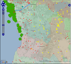
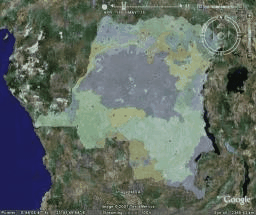
WarViews comes in two "flavors": The static version runs in a web browser and allows the user to switch between different datasets. The dynamic version is based on GoogleEarthTM and can animate geographic data such that the development over time can be monitored.
Static version |
|
 |
Requirements: Web browser, we recommend Mozilla Firefox.
WarViews static version |
Dynamic version |
|
 |
Requirements: You need to have Google EarthTM installed.
WarViews dynamic version |
Acknowledgements
We are grateful to the authors of the GIS datasets for their permission to include the data in our project. Many thanks to Jan Ketil Rød, author of the ViewConflicts software, for help and advice. Nils Weidmann is supported by ETH under Research Grant TH -4/05-3. WarViews relies on two OpenSource projects (GeoServer and OpenLayers) - we greatly appreciate the effort of the developers!